Friday, June 30, 2023

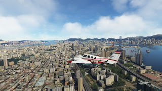
World Tour 2 - Leg 46 - Macao to Hong Kong

This will be probably one of the shortest but most interesting legs. One can cross from Macao to Hong Kong by road, either through China mainland or through the huge bridge I mentioned previously. However, one can also use a plane. What we can do in simulators is land at the iconic Kai Tak airport, closed and demolished in real life in 1998. This airport was one of the most dangerous in the World due the lack of instrumental approach from the North and the visual landing over residencial buildings. From 1912 till 1980s it was adequate for the region. However, during 1980s and 1990s, Hong Kong  lived a huge expansion of residential and commercial areas, to the point that the airport was surrounded by denser and taller areas. It became the third airport in the World in volume of passengers and cargo, which created noise and pollution issues. Therefore, it was decided to close it after building the current Hong Kong International Airport.

It has been so iconic that it is kept at simulators as an optional airport (as Meigs Field, at Chicago). And I cannot let this opportunity pass by, so I take off from Macao, enjoying another taxiway on a bridge, and keep a very low altitude towards Cheung Chau island, where the NDB used for visual approach to Kai Tak is located.


From here, I pass to full manual control and fly towards the next NDB, right at the city, from where a right turn in descent leads to the runway. Everything happened too fast, but I had time to take some pictures.


Amazing approach and landing. Definitely I will come back with an airliner. And now, let's think about the next leg.

------

Technical details:
 
VMMC VHHX

DALU SOKO CHEUNG-CHAU

Distance: 40 nm
Average GS: 200 kt
Altitude: 2,000 ft

METAR:

VMMC 301630Z 18012KT 9999 FEW015 30/27 Q1005 NOSIG
VHHH 301630Z 19007KT 160V240 9999 FEW016 30/25 Q1006 NOSIG


World Tour 2 - Leg 45 - Haikou to Macao

As I mentioned in the previous log, I intended to fly towards Macao. Luckily, I found 5 passengers willing to pay me for the same trip. So I took off from Haikou airport, heading towards Qiongzhou strait.


From here, I followed the coast along Guangdong province. There are plenty of villages and fields along it, as well as beaches and some industry. Similar panorama till reaching Macao, where things dramatically change.


Macao is a Special Administrative Region of China, formerly a Portuguese colony, which makes an interesting mix between Chinese and Portuguese culture and architecture. Its skyline is beautifully seen from the approach, as well as a long 55 km bridge-tunnel that connects Macao with Hong Kong, considered the longest sea bridge-tunel system in the World.


The runway is directly at the sea and the taxiways are bridges leading to the terminal, located on a small island and conveniently located next to the most important casinos.


Very interesting place. I didn't know anything about this city and its surroundings, so it has been a great experience. And now, I barely have time to rest, since there's plenty of people wanting to visit Hong Kong, and so do I.

------

Technical details:
 
ZJHK VMMC

PUGIAN ZHANJIANG MAOMING YANGJIANG CHIBIDAO ZHUHAI MCU

Distance: 280 nm
Average GS: 220 kt
Altitude: 5,500 ft

METAR:

ZJHK 301400Z 14002MPS 100V180 CAVOK 29/26 Q1004 NOSIG
VMMC 301530Z 18011KT 9999 FEW015 30/27 Q1006 NOSIG

World Tour 2 - Asian summary

Here I am, after so many months, at the end of the Asian section of the World Tour. I made a brief summary when I reached Paro, since it was...